Mostrando 967 resultados
Descripción archivística753 resultados con objetos digitales Muestra los resultados con objetos digitales

Report Number: 466 Laloki Dairy Farm Soil Description and Chemical Analysis, 3pp. Includes map with scale 1:2,500

Report Number: 469 Reconnaissance Survey of the Bewani Area West Sepik Province, 12pp. [Map not on file.] Includes map with scale 1:50,000
Report Number: 470 Broadview. Not carried out. [No file.]
Report Number: 470 Broadview. Not carried out. [No file.]
![Report Number: 476 Soil Survey of Mirigini and Borekepo Plantations, 22pp. [Map not on file.] Inc...](/pambu/catalogue/uploads/r/pacific-manuscripts-bureau/1/a/4/1a42f4973389de6653f01dea97f718ceff9e2020e6397572943b2e9aa0c71b83/PNG_DAL_LUS_report_476sma_142.jpg)
Report Number: 476 Soil Survey of Mirigini and Borekepo Plantations, 22pp. [Map not on file.] Includes map with scale 1:12,000
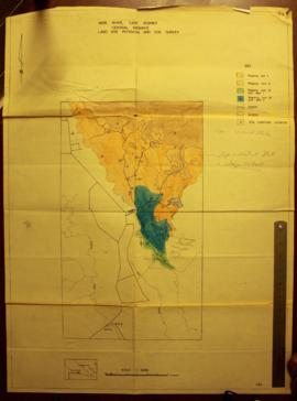
Report Number: 484 Mori - Domara Land Use Potential. Map only: Mori River, Cape Rodney, Central Province, Land Use Potential and Soil Survey. Includes map with scale 1:50,000

Report Number: 494 Urimo Livestock Station. Urimo Livestock Station Reconnaissance Visit Report, East Sepik Province, 21pp. Includes map with scale 1:115,000

Report Number: 499 Soil Survey and Land Use Potential of the Aroa River Area Central Province., 110pp. [No map on file.] Includes map with scale 1:100,000
Report Number: 502 Popondetta Oil Palm Scheme Study. [File missing.] Includes map with scale 1:100,000
Report Number: 502 Popondetta Oil Palm Scheme Study. [File missing.] Includes map with scale 1:100,000
Report Number: 517 Kokoda Valley Vegetation Map. [No Map. File missing.]
Report Number: 517 Kokoda Valley Vegetation Map. [No Map. File missing.]

Resultados 91 a 100 de 967