Mostrando 967 resultados
Descripción archivística753 resultados con objetos digitales Muestra los resultados con objetos digitales

Report Number: 516 The Proposed Resettlement Scheme Moitaka, National Capital District, 30pp. Includes map with scale 1:5,000

Report Number: 485 Menyama Survey. Land Use Study Menyama District, Preliminary Report Menyamya Major Environment (Anga Development Authority), 36pp. Includes map with scale 1:250,000
Report Number: 492 Kaliai Cattle Project W.N.B. G.R. Tyrie, 'Kaliai Cattle Project Land Use Potential Asssessment, West New Britain', Dec 1981, Ts., 26pp. With G. Murray, 'Proposed Kaliai Cattle Project Report, West New Britain Province', May 1982, Ts., 30pp. (which includes, 'The potential for development of grassland in West New Britain', and Jill Grant & Marty Zalenietz, 'Horticulture in the Kilenge Area: potential for development'; 'Pig husbandry in the Kilenge/lolo area: some implications for cattle projects'. Includes map with scale 1:100,000

Report Number: 492 Kaliai Cattle Project W.N.B. G.R. Tyrie, 'Kaliai Cattle Project Land Use Potential Asssessment, West New Britain', Dec 1981, Ts., 26pp. With G. Murray, 'Proposed Kaliai Cattle Project Report, West New Britain Province', May 1982, Ts., 30pp. (which includes, 'The potential for development of grassland in West New Britain', and Jill Grant & Marty Zalenietz, 'Horticulture in the Kilenge Area: potential for development'; 'Pig husbandry in the Kilenge/lolo area: some implications for cattle projects'. Includes map with scale 1:100,000
Report Number: 497 Report on Land Inspections Bereina Area, Central Province, 21pp. [No map on file.]

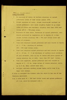
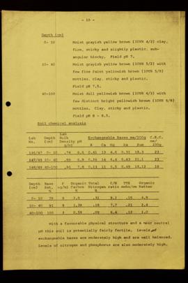
Report Number: 499 Soil Survey and Land Use Potential of the Aroa River Area Central Province., 110pp. [No map on file.] Includes map with scale 1:100,000

Report Number: 499 Soil Survey and Land Use Potential of the Aroa River Area Central Province., 110pp. [No map on file.] Includes map with scale 1:100,000

Report Number: 499 Soil Survey and Land Use Potential of the Aroa River Area Central Province., 110pp. [No map on file.] Includes map with scale 1:100,000


Resultados 21 a 30 de 967