Affichage de 97 résultats
Description archivistique97 résultats avec objets numériques Afficher les résultats avec des objets numériques
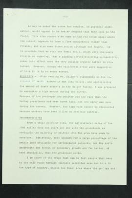
Report Number: 287 Jimi Valley Reconnaissance Survey, including Survey of Lower Jimi Valley Resources, with Map287, 'Lai Ruti Grasslands Lower Jime Valley; and 287A, 'Map to accompany investigation report on Mejimp Grasslands Lease Lower Jimi Valley', 23pp. Includes map with scale 1:50,000; 1”= 1 mile
Report Number: 287 Jimi Valley Reconnaissance Survey, including Survey of Lower Jimi Valley Resources, with Map287, 'Lai Ruti Grasslands Lower Jime Valley; and 287A, 'Map to accompany investigation report on Mejimp Grasslands Lease Lower Jimi Valley', 23pp. Includes map with scale 1:50,000; 1”= 1 mile
![Report Number: 279 Natural Drainage Map Gumanch Kugimi Swamp. Peripheral swamp area. [Map only.] ...](/pambu/catalogue/uploads/r/pacific-manuscripts-bureau/1/5/3/1536972f52ac7328afe684850db16b0bf2f83992a17ca54599b8f3daf5eabe79/PNG_DAL_LUS_report_279sm_142.jpg)
Report Number: 279 Natural Drainage Map Gumanch Kugimi Swamp. Peripheral swamp area. [Map only.] Includes map with scale 1”= 40 chns
![Report Number: 278 Gumant Swamps [Northern] Catchment Area. [Map only.] Includes map with scale 1...](/pambu/catalogue/uploads/r/pacific-manuscripts-bureau/5/6/c/56cd60c9888c457a8b5da51a89e6bec7592d26e3b9b9a12a557631a7a43f026e/PNG_DAL_LUS_report_278sm_142.jpg)
Report Number: 278 Gumant Swamps [Northern] Catchment Area. [Map only.] Includes map with scale 1”= 40 chns
Report Number: 277 Natural Drainage Map Gumanch Kugimi Swamp. (Natural drainage of proposed areas.) [Map only.] Includes map with scale 1”= 40 chns
![Report Number: 276 Natural Drainage Gumanch-Kugimi Swamp. (Proposed areas.) [Map only.] Includes ...](/pambu/catalogue/uploads/r/pacific-manuscripts-bureau/8/8/6/886584872d1455bc5d0f3fc734bccc3d61216804cd580cfc6546c91204c2e31a/PNG_DAL_LUS_report_268sm_142.jpg)
Report Number: 276 Natural Drainage Gumanch-Kugimi Swamp. (Proposed areas.) [Map only.] Includes map with scale 1”= 40 chns
Report Number: 252 Soil Survey Portion Baiyer-Muga Land, 23pp. Map Nos.252 & 252A. Includes map with scale 1”= 10 chns

Résultats 31 à 40 sur 97