


Área de identidad
Código de referencia
AU PMB PHOTO 127
Título
Fecha(s)
- January - September 1971 (Creación)
Nivel de descripción
Colección
Volumen y soporte
282 digitised 35mm slides
Área de contexto
Nombre del productor
Historia biográfica
John Baker worked as a volunteer under the auspices of the British Voluntary Service Overseas (VSO) organisation in 1964-1965. He was 18 and 19 at the time and was what was known as a ‘school leaver’ volunteer. John was attached mainly to two District Administrations to work on various local projects. August-November 1964, Baker worked as a teacher at the Geological Department’s survey school in Honiara. Then he transferred to Western District headquarters in Gizo and worked during December 1964 and January 1965 as a surveyor on the Wagina Island Gilbertese resettlement scheme. In February 1965 he transferred to Eastern District headquarters in Kira Kira where he spent six weeks working on local election preparations. He then moved back to Gizo and spent April to August 1965 travelling round, organising the construction of concrete drinking water tanks in various villages in the Roviana and Wana Wana lagoons and subsequently on the island of Ranonnga.
John Baker’s work in Solomon Islands prompted a long-term interest in the Pacific Islands and saw him work as Government Economist in Tonga in 1969-70. He later lived in Fiji and Tonga in 1971, while he undertook research for an ANU PhD on inter-island shipping services in the two countries. In 1976-77, while working in the Australian Government’s aid organisation, he was head of the Pacific Islands Section. Finally, after three years as an Australian Ambassador in Africa John Baker returned to working on the Pacific Islands when in 1991-97 he was Coordinator of the World Bank’s South Pacific Development Management Program. The program ran one-week residential management programs for senior government officials from across the region, with a number of participants later becoming heads of government in their countries.
Institución archivística
Historia archivística
Origen del ingreso o transferencia
Área de contenido y estructura
Alcance y contenido
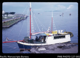
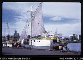
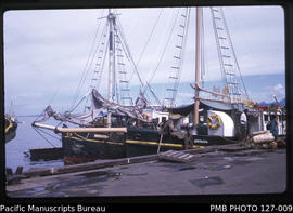
These slides were taken by John Baker while he was undertaking fieldwork for a PhD at the Australian National University (ANU) on the relationship between shipping transport costs and patterns of spatial development in Fiji and Tonga. John and his wife Liz (Elizabeth) lived in Suva and Nuku’alofa and were fortunate to travel extensively by ship around Fiji, as well as visiting the Vava’u Group in Tonga. The collection mostly includes ships and other vessels (including Japanese fishing boats, punts and whaleboats), as well as shipping infrastructure. It also includes landscapes, street scenes and personalities encountered.
In Fiji, shipping infrastructure includes Queen’s Wharf, Suva Wharf and the CSR (Colonial Sugar Refinery) wharf/jetty in Lautoka. Cargo is loaded and unloaded, including sugar, cars, timber and copra. Businesses include Pacific Fishing Co. and Morris Hedstrom. People photographed are Barry Shaw, Bill Erich, Dorothy Toussaint, Ian Fairbairn and Heidi Fairbairn and their son John Fairbairn, Liz Baker and John Baker, as well as the ANU House caretakers Manuele and Asenat. Places photographed are Sigatoka, Walu Bay, Deuba, Mualevu village and Lomoloma at Vanua Balavu / Mbalavu Island, Munia Island, Cikobia Island, Korotoga, Levuka, Yacata Island, Kanacea Island, Nayau Island, Naivaka Village, Bua coast of Vanua Levu Island, Nadura, Macuata coast, Undu Point, Somosomo, Taveuni, Taveuni coastline at Naikelemusu, Rewa Delta and Laucala Bay, Suva. There are general views of sugar cane / sugarcane fields and other agriculture (including rice, copra and use of bullocks), coral reefs, Suva housing, including new and informal housing, as well as the ANU house at 30 Beach Road.
In Tonga, photographs include shipping and other vessels (including steel barges, cutters, landing craft, sailing boats and others), as well as shipping infrastructure at Faua Harbour, Touliki Harbour, Neiafu wharf and Queen Salote Wharf at Nuku’alofa. Ships carrying passengers and cargo. Places photographed are Makaha'a Island, Pangaimotu Island, Tokulu Island in Ha'apai Island Group, Ha'afeva Island, Pangai village on Ha'apai Island, Vava’u Island (including abandoned airstrip), Onetale Bay and Neiafu town. People photographed are Liz Baker, Bill Toussaint and Elizabeth Toussaint. Scenes include coral blocks for Langi tombs, lakes, horses, vanilla gardens, Wesleyan church and Burns Philp store, amongst others.
Selection of slides for digitisation was made by John Baker.
Valorización, destrucción y programación
Acumulaciones
Sistema de arreglo
As arranged by John Baker
Área de condiciones de acceso y uso
Condiciones de acceso
Available for reference
Idioma del material
Escritura del material
Notas sobre las lenguas y escrituras
Características físicas y requisitos técnicos
See individual items
Instrumentos de descripción
Área de materiales relacionados
Existencia y localización de originales
Person: John R. Baker
Country: Australia
Existencia y localización de copias
Access this title at PMB Member Libraries or by contacting the Bureau directly: http://asiapacific.anu.edu.au/pambu/accessing.php
Unidades de descripción relacionadas
Área de notas
Notas
Photo captions written by John Baker at the time the photos were taken.
Notas
See also PMB PHOTO 114 and PMB PHOTO 126.
Identificador/es alternativo(os)
Puntos de acceso
Puntos de acceso por materia
Puntos de acceso por autoridad
- Baker, John R. (Materia)
Tipo de puntos de acceso
Área de control de la descripción
Identificador de la descripción
photo127
Identificador de la institución
Reglas y/o convenciones usadas
Fechas de creación revisión eliminación
Idioma(s)
Escritura(s)
Fuentes
Objeto digital metadatos
Nombre del archivo
Digital_reference_image.pdf
Latitude
Longitude
Tipo de soporte
Texto
Mime-type
application/pdf